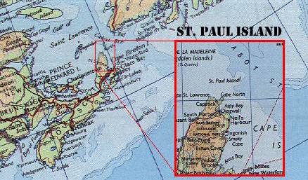
Where and What is St. Paul
Island? ![]()
 |
We will probably be going to the North Island. It is for all intents and purposes deserted, with an automatic lighthouse that we will not have access to. No power, water, shower, food, trees, although there is some shelter however. There are two buildings,.one resembling a house and 3m x 3m shed. One VLF beacon tower could be used for 160m and to hang other antennas off it.
Therefore we must take everything we need including food, water, first aid etc. There is no phone, TV, radio, power, or anything there. The North Island was manned until 1991, so the two buildings are in good repair according to our contact in the Coast Guard Maintenance Service. St. Paul is known to be the second most dangerous island in north-east Canada, possibly all of north-east North America. Its nickname is The Graveyard of the Gulf. Its layout is the complete opposite of Sable Island, being composed completely of jagged rocks. It rises steeply out of the frigid waters to a small plateau area that is scarcely 100m x 100m.
The South Island of St. Paul is much larger, but the buildings there are in a bad state of repair, having not been manned since the 1960s. Also the two safest landing spots that have buildings are both in sheltered coves, blocking the shot to Europe or USA by 175-200 foot mountains. The North Island is out in the open, 125 feet or so above the ocean surface. The island has slightly rounded top-no trees or mountains.
![]() Click here to go back to the CY9
Dxpedition page
Click here to go back to the CY9
Dxpedition page